The North Devon coast runs from Foreland Point, just
beyond Lynton and Lynmouth, on the Exmoor Devon/Somerset border and all points
in between until the Devon/Cornwall border at Welcombe.The main popular tourist beaches are Croyde, Instow, Saunton Sands, Tunnels, Ilfracombe, Woolacombe and Westward Ho! As you trace a map along the South West Coast Path there are many, many more each with their very own unique features and geology including amazing craggy cliffs, rock formations, rocky shores with rock pools and sandy inlets. These can be found abutting green fields, coastal meadows and sand dunes but there are quite a few remote and not easily accessible ones below towering cliffs. Before you venture out to that so called "Hidden Gem" take a good look at the Marine Conservation Good Beach Guide or the RNLI Respect the Water site particularly if you are doing any sort of watersports like Surfing, Kite Surfing or Paddle Boarding.
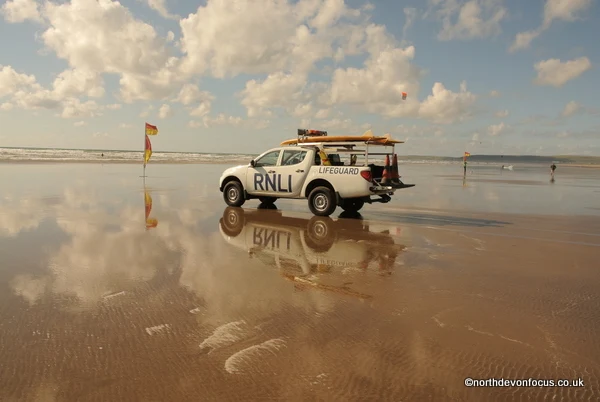
Remember always let someone know where you are going, check tide times, great care must be taken in the water, beneath the cliffs and waterfalls. Be safe the RNLI Beach Lifeguards are on duty in the main tourist season at Croyde Woolacombe, Sandymere and Westward Ho! The rest of the time you are on your own especially if you choose a remote location always have a buddy on the shore and consider whether there will be a mobile signal.
If you are a walker, rambling along the South West Coast Path, check for any route changes before you set off, you will no doubt want to explore and rest awhile on an inviting cove below but think before you go down any steep steps or paths, especially if it's been raining.
Here are just some of the glorious rocky coves and beaches on our North Devon coast starting at Lynmouth, Woody Bay Wringcliff, Woody Bay, Combe Martin, Ilfracombe: Hele Bay, Ilfracombe: Wildermouth Ilfracombe: Tunnels Beaches, Lee Bay, Rockham Bay, Combesgate Beach, Barricane Beach, Woolacombe Sands, Putsborough Sands, Croyde Bay, Saunton Sands, Instow, Sandymere, Westward Ho!, Greencliff, Bucks Mills, Hartland Quay, Spekes Mill, Shipload Bay, Welcombe. (Scroll down for map). They are not all classed as "Bathing Beaches" so for all North Devon Beach location details, useful information and water quality data visit the official Marine Conservation Good Beach Guide You can also keep up to date with real time water quality alerts by downloading the Surfers Against Sewage Free Safer Seas Service app
Photos: The Blue Flag Beach at Westward Ho! copyright Pat Adams (All rights reserved)
---------------------North Devon beaches receive national recognition
**Croyde Beach won the prestigious Blue Flag Beach Award in 2023
**Woolacombe Beach Voted Number 1 in the UK on Tripadvisor (February 2016)
**Woolacombe Beach Voted Number 1 in the UK on Tripadvisor (February 2016)
**Woolacombe was selected as The Sunday Times Best Beach of 2021
**Westward Ho! is an award winning Blue Flag Beach. The Blue Flag is the international standard for the best beaches in the world.
**Westward Ho! is an award winning Blue Flag Beach. The Blue Flag is the international standard for the best beaches in the world.
---------------------------------
In March 2022 *North Devon was formally announced as the 12th
World Surfing Reserve alongside iconic surfing locations around the world -
North
Devon Surf Reserve.
--------------------
UK Beach Guide - 12 Beautiful North Devon Beaches
-----------------
----------------------------------
TIDE TIMES
- Easytide - North Devon Tide Prediction (Admiralty Maritime Data Solutions)
- Tidechart.com provide tides to over 600 locations in the UK. >TAP HERE for tide and marine information for Devon Weekly Tides - Weather Fishing Tides - Regions and cities in Devon
- Devon Tides.com - >TAP HERE check tide times around Devon
-------------------------------
For all North Devon Beach Location Details & Water Quality Information TAP HERE for official Marine Conservation Good Beach Guide
For all North Devon Beach Location Details & Water Quality Information TAP HERE for official Marine Conservation Good Beach Guide
Be prepared for the great outdoors
BBC Weather Forecast - RNLI Safety Respect the Water -
Met Office: Weather - The Environment Agency - North Devon Tide Prediction - Maritime & Coastguard Agency Countryside Mobility Southwest
BBC Weather Forecast - RNLI Safety Respect the Water -
Met Office: Weather - The Environment Agency - North Devon Tide Prediction - Maritime & Coastguard Agency Countryside Mobility Southwest
-----
RNLI Advice on Cold Water Swimming
Beach Safety - Recognise the Signs
Understand the Sea - Learn about Rip Currents
------------------
Ordnance Survey Maps
Beach Safety - Recognise the Signs
Understand the Sea - Learn about Rip Currents
------------------
Ordnance Survey Maps
- Map of Clovelly & Hartland - Explorer 126 -
- Map of Bideford, Ilfracombe & Barnstaple - OS Explorer Map 139 (Woolacombe & Lundy) -
- Barnstaple & Ilfracombe - Paper maps | Landranger 180 -
- Bude & Clovelly - Landranger 190 -
- Map of South Molton & Chulmleigh - OS Explorer Map 127 (King’s Nympton, Chittlehampton & Dolton) -
- Map of Exmoor National Park - OS Explorer Map OL9 (Barnstaple, Lynton, Minehead & Dulverton) -
- Minehead & Brendon Hills - Landranger 181
North Devon Focus on
Tap here for North Devon Action Focus


No comments:
Post a Comment